

|
"[I]t's way harder than running a hundred mile race."—Ultrarunner Catra Corbett about her experience as part of team Racing with Giant Dirty Avocados. Get Lost!! in Henry CoeU.S. Rogaine Championships (24 hours), with 4 and 8 hour divisions. On foot. 


We have
Visit RouteGadget to draw your route, or to share your GPS track. For an introduction to RouteGadget, see this page. The map has been georeferenced and the tracks need no adjusment. For this event, selecting "View routes" will show each team's checkpoint order even if no route or track has been entered. On the first weekend of November, 156 adventurous souls—62 teams—scaled the slopes of Henry Coe State Park, braved the rain and chilly nighttime temperatures, and Got Lost!!... at least a few of them did, anyway. The hardiest ones—26 teams!!—participated in the 24 hour event, which served as the 2011 U.S. Rogaine Championships. Supervet teams (those over 55) dominated the field! Nothing like old bones to withstand the rain. Aside from the impressive performance of Team Eastern Europe, which covered the most distance and climbed the most mountains to take the overall and Open Men's win, the highlights all belonged to very experienced folks: phast Generation, hailing from Vermont and Maryland, took the second place in Open Men—and a win among the Masters. Team Proceeding On, from Colorado and Illinois, was fifth overall—and took the Open and Masters Women win. And Nightcrawlers from New York State, yet another Supervet team, were just 40 points behind the overall Mixed winners, locals Racing with Giant Dirty Avocados. These five teams qualified for the 10th World Rogaining Championships, which will be held in early September of 2012 in Czech Republic. Few teams managed to keep moving through the dark hours; those who did were guaranteed a high place in their category. Those who decided to crash for the night found welcome at the remote aid station, where hot food was on offer through most of the event. Some teams went as far as to plan multiple stops at the remote aid, or a stop at the aid and a pass through the main hash house. At the risk of sounding like know-it-alls, think layers for next time! although typically the first week of November is one of the last dry and warm weeks of fall in the Bay Area, 2011 was anything but typical. We won't be offering a 24 hour rogaine in 2012, but join us for an adventure no less epic: Henry Coe Adventure Trex! Run/camp/run, or bike/camp/bike, or hike/camp/hike, and spend up to 40 hours with Mr. Coe. Cover tens of miles, climb a few mountains, enjoy the views across expanses of oak land, navigate under the stars, and catch up with old friends and make new ones at the camp! There will also be a 4 hour rogaine for those with smaller appetites. We plan to hold one or two 24 hour rogaines in 2013, at Coe and a new Northern California venue being developed. One of them will again be a bid for U.S. Rogaine Championships. And if you can't wait this long—and would like a shortie warmup before the Adventure Trex—MerGeo is putting on its Three15er, a bid event for the North American Rogaining Championships, on 29 and 30 September 2012 in the general area of Yakima/Ellensburg, Washington. Here are a few other things we'd like to mention:
The 2011 event wouldn't have been possible without tremendous amounts of your help. We would like to thank the following volunteers and staff:
A part of the event proceeds benefits the programs of Team USA Orienteering and BAOC COOL. Get Lost!! in Henry Coe staff: Vladimir Gusiatnikov Learn from our mistakes!
Location and the BasicsExplore the wild... Explore yourself! It will be something like this... but with less than 12 hours of daylight:
Thanks to Tamil Tigers Peoples Liberation Revolutionary Front, who chronicled their team's journey through Henry Coe, 2010, in this video. The video also features Team Keyser Soze & the Usual Suspects. In the backyard of Silicon Valley, there's a special place called Henry Coe State Park. Tens of thousands of acres of beautiful wilderness—oak forest, pine forest, grasslands, and some chapparal. Trails, major and minor. Prominent peaks and long, meandering valleys. Gather a team of 2 to 5 adventurers. (Solo is okay on the 4 hour course.) We'll give you 4, 8, or 24 hours to complete a course that no team can possibly finish. Prioritize and plan a good route to maximize your point scoring. Or just plan to have a grand adventure! You'll be using a custom-made map with accurate elevation contours, trails, and vegetation coloring. Find up to 62 checkpoints—a compass is recommended to locate the ones off the trail. Over 100 racers came to Coe last time for our inaugural Get Lost!! in Henry Coe rogaine. With the U.S. Rogaine Championships and longer courses, we're expecting an expanded field—a great event for the casual adventurer and the serious competitor!
The start/finish/parking are on the edge of the map; a second base camp/aid station will be open in the approximate center of the mapped area, with hot food, communications, first aid, and opportunities to camp and sleep. We will transport your equipment and set it up there. This map was used at the 2010 event:  Our Sponsors!! This event has been made possible by the following businesses and organizations. We are delighted to offer a sampling of their products as prizes for this event. Please patronize their offerings and services, and contribute to their programs:
Event ScheduleFriday 04 November EDT = GMT–07:0010:00 Check-in and packet pickup open, Zombie Runner store 18:00 Check-in and packet pickup close Saturday 05 November EDT = GMT–07:0006:30 Check-in and packet pickup open, Hunting Hollow entrance 07:34 Sunrise 08:00 Maps are handed out, all divisions except Sunday 4 hours 08:45 Briefing, 8 hours 09:00 Start, 8 hours 09:45 Briefing, Saturday 4 hours 10:00 Start, Saturday 4 hours 10:30 Check-in and packet pickup close 10:45 Briefing, 24 hours 11:00 Start, 24 hours 13:00 Aid station opens 13:30 Food service begins, start/finish 14:00 Finish, 4 hours 14:30 4 hour teams not finished are disqualified 15:30 Food service begins, aid station 17:00 Finish, 8 hours 17:30 8 hour teams not finished are disqualified 18:00 Awards, Saturday divisions 18:06 Sunset Sunday 06 November EST = GMT–08:0001:00 Daylight savings time ends 06:30 Check-in and packet pickup reopen 06:35 Sunrise 07:00 Maps are handed out, Sunday 4 hours 07:30 Registration closes 07:45 Briefing, Sunday 4 hours 08:00 Start, Sunday 4 hours 08:30 Food service ends, aid station closes 10:00 Finish, 24 hours 10:30 24 hour teams not finished are disqualified 11:15 Awards, 24 hours 12:00 Finish, Sunday 4 hours 12:30 4 hour teams not finished are disqualified 13:00 Awards, Sunday 4 hours 13:30 Food service ends, start/finish 17:05 Sunset
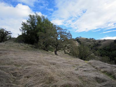
All the Details!In this section: 1. Event descriptionGet Lost!! in Henry Coe is a rogaine. About 62 checkpoints scattered over the southern part of Henry Coe State Park will be circled on a map and marked on the ground by orange and white orienteering markers with SPORTident stations which create a record of your visit on a small electronic card each participant will carry. Each checkpoint has a point value, which is equal to the checkpoint number rounded down to the tens. For example, Checkpoint 68 would be worth 60 points. The objective is to score as many points as you can within the time limit by visiting checkpoints along your planned route. There are point penalties for returning late. Maps are issued well before the start, so that teams have time to plan their route. At each checkpoint visited, every team member must use her/his own SPORTident electronic card to "punch" at the SPORTident station (International Rule B16(a)). To accomplish this by distributing all of a team's SI cards to one person who goes and punches them all is breaking the rules. You may use your own SPORTident card, or rent one from us at no extra charge. The capacity of the largest SPORTident card is about 50 checkpoint records by default—but we think we have found a way for it to hold more, the so-called "extended mode reset". If it works, which we will verify about a week before the event, then there is no need for anyone to carry multiple SPORTident cards. Each team member will need Model 6 or Model 9 for the 24 hour event; if yours is a different model, we will loan you a Model 6 at no charge. 2. Event staffEvent Director: Rex WinterbottomEvent Consultant: Peg DavisCourse Designer: Vladimir GusiatnikovCourse Consultant: Bill CusworthMap Consultant: Eddie BergeronCourse Setters: Alexei Azarov, Bill Cusworth, Heidi Cusworth,Mike Minium, Eric Bone, George MinarikCartographers: Vladimir Kozlov, Vladimir GusiatnikovSafety Coordinator: Vladimir GusiatnikovFood Chief, Base Camp: Lani SchreibsteinFood Chief, Aid Station: Nadezhda PopovaCommunications Chief: Bob Cooley We will provide an expanded staff listing closer to the event. 3. The terrainThe terrain of Henry Coe State Park is hundreds of square kilometers (tens of thousands of acres) of gorgeous central coast wilderness. An equal mix of grassland and oak forest, most—but not all—of the acreage allows for rapid movement. That is, the main obstacle is the grade of the hillsides, not disagreeable vegetation. What makes route planning interesting is steep—sometimes super steep—hills and deep erosion features. There is some poison oak and chapparal, and expanses of each are mapped. The elevation is 260 to 810 meters—in the higher reaches you may encounter pine forest. There are some well-maintained roads and trails. Views are out to the Pacific Ocean on a clear day. A team's successful strategy will minimize traversing the steepest sections. It is always faster in this park to go up-and-over or take a trail with some detour; contouring (maintaining elevation) on hillsides is slow. The terrain in the western and the southern reaches of the mapped area is the steepest, and is perhaps at its most steepest right by the start/finish. If your team manages to get up to one of the ridges that tower above Hunting Hollow, what lies to the east and north is less steep, although also quite steep. The slowest parts of the map are the canyons that empty into Coyote Creek and into Hunting Hollow (itself) near the start/finish. Their north-facing sides are full of poison oak, south-facing sides are high in chaparral, walls are riddled with cliffs, and to go along streams that run down the canyons frequently means climbing over car-size boulders. You really don't want to be in these canyons. Other places your team won't want to be in are where contour lines run close to each other. As to wildlife, deer and newts are abundant. Wild turkeys are frequently spotted. This park doesn't have cows, so ground is soft and unbroken. Grass is typically low in November, although given one of the rainiest years on record, it may be taller than usual. 4. Potential hazardsHazards present in the terrain include:
In addition, there is a small chance of hypothermia at this time of the year. The chance of heat-related problems is exceedingly small. Henry Coe is mountain lion habitat. Chances of encountering the reclusive cat are very low. If you do, follow this protocol. If you turn around and run, the cat's mind will more likely identify you as prey. Poison oak produces an oil which may cause a delayed skin irritation reaction. Know what it looks like, avoid contact, and wash exposed skin areas with a detergent such as Tecnu®. We have attempted to map continuous, extended areas of poison oak that significantly impede movement. There is more of it than is mapped. This plant strongly prefers north-facing slopes. Ticks, if attached, are best removed by yanking out firmly with tweezers. If you later develop a rash, get tested for Lyme disease. Keep the offending tick in a plastic bag for the doctor if it managed to stay with you after the event. Usually ticks take more than several hours to transmit any diseases such as Lyme through their mouthparts into your bloodstream. The percent of ticks that can carry Lyme among all ticks in coastal California is low; the incidence of Lyme among these ticks is also low. Lyme is effectively treated with antibiotics. If left untreated, Lyme can evolve into a serious systemic disease that often leads to disability; fortunately, many of its effects are reversible with treatment. 5. Participant safetyParticipants will be responsible for their own safety while taking part. Of course, event staff will try to help you if we learn that you are seriously injured or otherwise need assistance, but there is a good chance you would be waiting a long time for help, and we don't have the level of staffing or expertise necessary to quickly and expertly handle many emergency situations that might arise, so your best bet is to be very careful not to get injured. If you are not comfortable assuming the risks involved in prolonged exertion while traveling through rugged terrain under various and possibly unexpected conditions, then you should not take part in the event. The terrain has steep, and some possibly unstable, slopes. These potentially dangerous areas are not explicitly delineated on the maps, so you will need to determine the safety of traversing a prospective route for yourself. Close contours indicate treacherous terrain. Each person will be required to sign a liability waiver when registering online or upon checking in for the event. A parent or guardian must sign for a minor. The organizers are not in a position to review each participant's preparedness to participate and will not do so. However, if it comes to the organizers' attention that a person or a team is poorly prepared for the event, the organizers may deny entry to that person or team in the interest of the safety of all the participants and staff of the event. The team aspect of the event is perhaps the best safety instrument. Team members must stay together within unaided voice distance, and must punch together at checkpoints. Not staying together will yield disqualification. There is some cell phone coverage on ridgetops, and at the aid station. We will provide a map that shows the approximate extent of the coverage. Participants are advised to carry cell phones. If there is an emergency, call 911 and also notify the organizers. At least one of our cell phones will be reachable at the aid station; this number will be on the front of the competition map. We plan to have communications between the start/finish and the outside world via a radio link between the start/finish and the aid station. If a team has indicated an emergency, it is the duty of all other teams who are nearby and hear the distress signal to help the team or participant in distress. There will be at least a licensed EMT, and quite possibly one or more medical doctors, among the participants. Each team will be required to fill out an intention sheet, which is a copy of the competition map, with their intended route. The actual route taken does not have to exactly match the intended route. Intention sheets are due at the briefing 15 minutes before the respective start. The two main dangers that exist for participants of an ultralong endurance event are dehydration and hyponatremia. We will provide water on the course. However, to be on the safe side, teams may wish to carry a water purification device, such as a portable filter or iodine tabs. This late summer has been quite dry. There is not a lot of water in the creeks, some are completely dry; water in ponds is stagnant, but should be safe to drink after filtering. There are no water fountains/treated water sources/running water at the park bathrooms. All teams should carry reservoirs that are large enough to sustain the team members between water stations. Consuming enough salt will mean the difference between being sluggish and not thinking clearly, and being sharp and enjoying the experience throughout the whole duration of the event. Take salt pills or eat salty food starting at 3 hours into the event at the latest; 200–400 milligrams of sodium ion per hour are advised. Drinking only plain water depletes sodium in your body. Other electrolytes may also help prevent cramps. We suggest carrying electrolyte pills if you plan on doing the 8 hours or the 24 hours. The safety bearing is west to Gilroy Hot Springs Road or Cañada Road; this will be noted on the competition maps. We have a safety and search/rescue plan you may peruse. Information on this webpage supercedes the Safety Plan, where contradictory. If you have any questions about information in this section, please contact our safety coordinator. 6. The competition mapThe map will be 1:20,000 with 10 m contours. We will offer high-legibility printing. The whole area will be on a single map sheet. We do not feel that waterproof paper is needed for this event. We will provide plastic map cases of appropriate thickness. The primary source of data for this map is Santa Clara County lidar survey done in 2008. Raw data from this survey has been provided by the USGS. The USGS processed this data into a digital elevation model, which we used for the elevation contours. Raw lidar data has been processed by our bivariate kernel density estimator in search for vegetation classification and boundaries. Where results have been satisfactory, our duo of cartographers is now striving to bring you the best possible standard of vegetation depiction. For about half of the area used at our 2010 event, we determined vegetation boundaries from high-resolution photos. For most of the rest of the 2011 area, vegetation boundaries and density are digitally derived from the lidar data, with some human oversight. Where this has not been possible (a minority of the map), vegetation will be simplified. The size of the mapped area will be between 70 km² and 75 km². The symbols we use on this map will be largely the same as those we used on last year's map. Maps will be printed to magnetic north, and will have a UTM grid (no indication of true north). A. CONTOURS: The contours are the most reliable and consistent component of the map. The quality of the contour base is uniform throughout the map, and the absolute accuracy is better than ±10 m lateral, ±2 m vertical. What this means is that each and every single-contour reentrant is there. The contours are unaltered by field survey, which could only make them worse. Unlike the 2010 version, the 2011 map will have index contours and spot heights. B. TRAILS AND PONDS: All trails and ponds are from high-resolution aerial photos, complemented by GPS survey in the field. Their accuracy is such that you won't be disappointed. All official park trails are shown, plus others in various states of disuse. Mapped trails can be used for navigation without reservations. C. VEGETATION: The positional accuracy is better than ±10 m lateral, referenced to the contours or to UTM. All distinct single trees and bushes are shown. We use the following grades of vegetation:
We use a vegetation boundary symbol (a solid green line) between all areas of different types to aid readability. This does not mean that all of these boundaries are distinct. We also use a symbol for a gap that looks like a trail, but is skinnier and has longer dashes. This symbol denotes long and narrow breaks in the canopy; there is almost certainly no matching trail on the ground. The use of color on this map is not the same as it is on an orienteering map; all of the vegetation symbols are green or white. We feel that the two-color scheme is most appropriate for low-light map reading. D. STREAMS: The streams are from USGS quad data. E. ROCK AND FENCES: There are some spectacular, towering rock features, and in general quite a bit of rock in this terrain. There are many fences; all of them are of the regular five-strand barbed wire variety, dating back to when the park was an active ranch. Most of these fences are well on their way to decomposition, and are easy to climb over. We made a decision not to extensively survey the cliffs or the boulders, only putting in what was immediately apparent in the photo and/or gigantic in the terrain. No fences have been surveyed or shown. The official park map can be obtained from many outdoor stores: ISBN 0-9700007-9-0. This map does not depict vegetation. Its contour base appears directly inherited from USGS 1:24,000 data. The trail network on this map was GPS'ed by park volunteers, and is exquisitely accurate and complete as far as the official trails. 7. Course specificsThere will be about 62 checkpoints, totaling 3600 points. The optimum distance to get them all and to stop at all water stations and the aid station will be between 70 and 75 km along straight lines. Climb on this route will be between 7% and 8% of the actual distance traveled. This course is enough to keep even the World Champion rogainers awake for the full 24 hours. The number of points awarded for visiting a checkpoint is the first digit of the checkpoint's code, times 10; for example, Checkpoint 68 is worth 60 points. The penalty for being late is 10 points per minute, or fraction thereof. Teams finishing more than 30 minutes after the deadline will be disqualified and will get a score of 0. Most locations are technically easy to moderate, while a small number are hard or very hard. We will assign values to checkpoints based on their combined navigational and physical difficulty. In other words, don't expect a gimme from an 80-pointer. There will be five water stations. These locations will not be at checkpoints, and will not be worth any points. Most of these stations will be at one of the park's many natural springs, and so will not have water containers. Instead, we will place a high-throughput water filter. The filters are advertised at 0.5 liters/minute, and we haven't tested them. So, plan on spending a little bit more time filling at each station than if the station had pre-filled water jugs. There will be a trash bag at each water station. You are allowed to dispose of your trash into these bags, but not elsewhere on the course other than the start/finish and the aid station. There will not be any other drinks, food, or supplements at the water stations. Each checkpoint will be equipped with an orange and white orienteering control marker, a SPORTident electronic station, and a red, white, and blue reflector. There will not be sign-in/intention sheets at checkpoints. Water stations will have reflectors, but not orienteering markers or SPORTident. A very small number of checkpoints and water stations may be manned. The orienteering marker may have a number/code that will not match the checkpoint code. The correct code is shown on the SPORTident station. To punch, put the SPORTident tag through the opening. If there is no confirmation beep nor a light flash, use a paper punch attached to the control marker to punch your map. If you are unable to find the checkpoint but think you are in the right location, take a picture. All locations will have been verified with GPS. All team members must punch the SPORTident station within 60 seconds (first to last) in order to claim credit for the checkpoint. 8. Aid stationBecause the staging area at Hunting Hollow is not central to the course, there will be an additional staffed aid station at Willson Camp with hot food service. This is the location marked with a bucket on the 2010 map. There is a bathroom at this location, but no other permanent facilities. The aid station will be open, and food will be served, as specified in the event schedule. The menu will be the same as at Hunting Hollow. The aid station will also feature a supply of energy gels by GU Energy. Because we believe a rogaine should test the ability of a team to navigate long distances, not to haul sizeable backpacks, we are offering all teams the opportunity to transport their gear to the aid station, and to set up their tents. The equipment will depart Hunting Hollow promptly after the start with most of the aid station's staff and supplies, and will return before the 24 hour finish. The park has a limit on the number of vehicles we are allowed to drive. Consequentially, the weight limit for this equipment is 10 kg/22 lbs per team. We will only charge for this service if we have to set up a tent, or do something involving a similar amount of labor. Reasonably-sized drop bags are free and encouraged, and will be available at the aid station per the schedule. The aid station opens up a number of possibilities for teams. The top teams will undoubtedly spend the whole 24 hours on their feet, perhaps stopping at the aid station, perhaps not. Those less competitive may enjoy crashing at the aid station for a few hours; it is a lot more welcoming plan than to rest back at Hunting Hollow, the lowest point of the course. Teams out to enjoy themselves, and perhaps competitive 8 hour teams, may want to use the aid station as a destination. There will be a SPORTident station at the aid station, however its use is not mandatory and is for route analysis purposes only. Visits to the aid station will not earn points. 9. Classes and categoriesThere will be three event divisions, the 4 hour, the 8 hour, and the 24 hour (the Saturday and Sunday 4 hour competitions will not be scored separately). Solo competitors are allowed in the 4 hour division, but not in the longer divisions. The maximum team size is 5 members. A team that has a member born after 1997 must also have a member born in 1993 or earlier. There will be the following gender classes:
A mixed team is one that has members of both genders. There will be the following age categories:
You may notice that these categories are slightly different from what Orienteering USA Rules for Rogaine Competition state. These Rules, and the International Rules of Rogaining, categorize teams by age on the first day of the event, not on 31 December 2011. A small number of teams may be affected by this distinction. If your team is, please contact us and we will ask Orienteering USA for clarification. The age on 31 December 2011 is what the rest of Orienteering USA Rules use. Every team is eligible for awards in the Open category. Some teams may fall into multiple age categories. In this case the team is eligible for awards in all categories in which they meet the criteria. Logical combinations of the above classifications will constitute awardable categories, for example, "24 hour Supervet Women" or "4 hour Junior Mixed". Categories with few teams will not be consolidated for the purposes of awards. 10. Scoring, results, and awardsAll teammates must stay within unaided voice distance and all must punch at a checkpoint in order to claim credit, within 60 seconds (first to last). If one team member is unable to continue, the whole team must report to the start/finish. A new team may be formed and it may then go on the course, but it will be unable to claim credit for checkpoints already visited. The number of points awarded for visiting a checkpoint is the first digit of the checkpoint's code, times 10; for example, Checkpoint 68 is worth 60 points. The penalty for being late is 10 points per minute, or fraction thereof. Teams finishing more than 30 minutes after the deadline will be disqualified and will get a score of 0. Teams will be ranked within their division, age, and gender categories according to their total score. Among teams with identical scores, the earliest finishing team will be ranked highest. Teams that are disqualified or do not finish do not get a place. (Every team that finishes within 30 minutes of the time limit, and does not break certain rules, gets a score. You don't have to stay out for the full 4, 8, or 24 hours! You can finish earlier if you feel like it.) Upon finishing, teams should proceed to a SPORTident download station. Points will be tallied, and each team will receive a copy of their score sheet that will contain checkpoint-by-checkpoint split times, the total straight-line distance traveled, and the approximate climb. U.S. Championship medals will be given at the award ceremony to all members of the top 3 eligible teams in each category of the 24 hour division. The eligibility criteria are quite simple:
So, why not join Orienteering USA? Top teams in all divisions, classes, and categories, whether eligible for U.S. Championship or not, will also get prizes from our sponsors. Event results, splits, and RouteGadget will be promptly made available online. 11. Weather and recommended clothing"Late summer" in the Bay Area sometimes creeps into early November, or the rainy season may get an early start. Typically, the weather is quite perfect for a long endurance event—sunny with highs in the 60s (+16– +21 °C) and overnight lows in the high 40s (+8– +10 °C). In the unlikely situation of "late summer", highs could be in the 80s or 90s (up to +35 °C). The chance of any rain showers during the event is probably at most 10%. There has not been any rain during the first week of November in each of the past 7 years. On the colder extreme, daytime highs could be in the low 50s (as low as +10 °C) and overnight lows in the high 30s (just above freezing). Layers are advised. Remember, we can transport your stuff up to the aid station. 12. The rulesOrienteering USA Rules for Rogaine Competition and the International Rogaining Federation Rules of Rogaining will be in effect, supplemented by this information (which includes some Rules deviations, subject to approval by our Event Consultant). When there is a conflict between the two sets of Rules, U.S. Rules take precedence. Here are a few rules highlights:
The required equipment is (we may modify this list up to one week before the event):
We will check this equipment before the start. Teams who do not possess it will not be allowed to start. 13. Suggested equipmentEach team should have a compass, shoes with treads appropriate for the steep slopes, salt tablets, food, blister tape, a first aid kit, and a space blanket. 14. Future closure of Henry Coe State ParkThe park was scheduled to close to the public sometime between September of 2011 and July of 2012, but the eventuality has been averted. Many thanks go out to Coe Park Preservation Fund, an arm of Pine Ridge Association, and personally to Daniel McCranie for making this possible. Get Lost!! hopes to hold rogaines and mountain marathon-like events at Coe Park for years to come. Event MenuWe will serve the same menu at the start/finish and at the aid station. Food will be served at an appropriate temperature according to the schedule.
The details of the pre-event Friday dinner are still being worked out. Just wanted to say thank you guys for such a fun event. It was a great navigation exercise and an awesome workout. I have also never been at an event with such great food! I don't even eat that well at home! —Stephanie, Team Racing With Giants Get Lost!! sold out its first independently produced event at Henry W. Coe State Park on 11 December 2010. The rogaine was one of a very small number of organized activities held in the park; one hundred and eight rogainers, orienteers, hikers, adventure racers, and ultrarunners took part. Two event durations were offered, 4 hours and 8 hours. The 8 hour event was won by Team TrackMe360 (Gerrell Elliott, Mats Jansson, and Dennis Wilkinson). Team SOAR of Redding took the mixed honors. Evil Geniuses for a Better Tomorrow blazed through the 4 hour rogaine at 12:43 min/km straight-line pace. The style of the map used for this year's event will be very similar to one used in 2010. Checkpoint placement will again be mostly easy and moderate, with a small number being technically hard and very hard. Travel and AccommodationsThe directions to the start/finish are here. The closest airport is San José International, 43 miles to the Hunting Hollow entrance start/finish. San Francisco and Oakland airports are also valid options. Gilroy Transit Center is reliably reachable by public transit; from there, it is a $35 (with tip) taxicab ride to Hunting Hollow. We recommend Hertz, an Orienteering USA partner, for car rentals. By booking through this link, you will be supporting U.S. orienteering and rogaining. Our discount code will be displayed on the reservations page. Packet pick-up will be at the Zombie Runner store on Friday, and on site on Saturday. There will be no camping at the start/finish on Friday night. Orienteering USA has negotiated discounted rates with its sponsor, Motel 6. The closest Motel 6 is in Gilroy, 12.0 miles from the start/finish. At the time of this writing, members of Orienteering USA were offered rates from $44.99 to $55.79 per night, plus tax. In order to get these rates, you must book through the Motel 6/Orienteering USA partnership program. By making your booking through this website, you will be supporting U.S. orienteering and rogaining. For camping, we recommend the Casa de Fruta Orchard Resort. (Note that this is a third-party website, and Casa de Fruta's own website appears to have no info about the campground or reservations. Please contact Casa de Fruta directly by phone for reservations.) Although the resort is not far from the boundary of Henry Coe, the drive to Hunting Hollow entrance is quite long, and takes at least 35 minutes. For activities in the Gilroy area, please check with our partner, the Gilroy Visitors Bureau. Entry and RegistrationWe have a registration limit of 260 participants, of whom at most 120 can be in the 24 hour division. This limit is due to both park constraints, and to the extent of what we can do while maintaining a quality experience for everyone. As of 27 October, the 24 hour event is 65% full, the event overall is 56% full.
All food during and after the event is included in the registration price, as is SPORTident rental for each team member. The T shirt is a high-quality o21e production; the sides will be rockin' black and the front and back, grey with the cougar design. A part of the event proceeds will benefit the training programs of Team USA Orienteering. Pre-registration is open. Team members may enter together (be entered by the same person), or separately. If you would like to go with a team, but don't know your teammates' names yet, you can enter yourself and other members can join the team at a later time. As with all events by Get Lost!!, fees for teams are capped. Three, four, or five people enter at the team price; each team member gets a map. The price for a team is determined when the last member joins it; additions after the deadline will increase the team fee. The fees are:
Discounts!!Orienteering USA is offering $20 off the entry fee for the 24 hour Championship division, per person, for first-time A event attendees. If you have never participated in a sanctioned Championship rogaine nor in national-level orienteering A event, simply print out the coupon, have it endorsed by us at the event, and mail it in. This is a rebate—you will pay the regular entry fee during our registration process. On top of these prices, we offer the following discounts:
The BAOC discount only applies to individuals, not teams. That is, a registration for two people who are both BAOC members will cost less than the team price. A three-person team is always best off taking the team deal. These discounts are taken and combined automatically by the registration system. Extras!!
Go register!! We maintain a discussion board for all our events on Attackpoint. Popular among map and adventure-sports athletes in the U.S., Canada, Australia, New Zealand, and other countries, the site is the one to go to for the latest navigation-sport news, schedules, discussion, and gossip. Forum for the U.S. Rogaine Championships. 

|


 As of 27 October, T shirts are
sold out. Teams and individuals who register after this date will automatically
receive the no-shirt discount.
As of 27 October, T shirts are
sold out. Teams and individuals who register after this date will automatically
receive the no-shirt discount.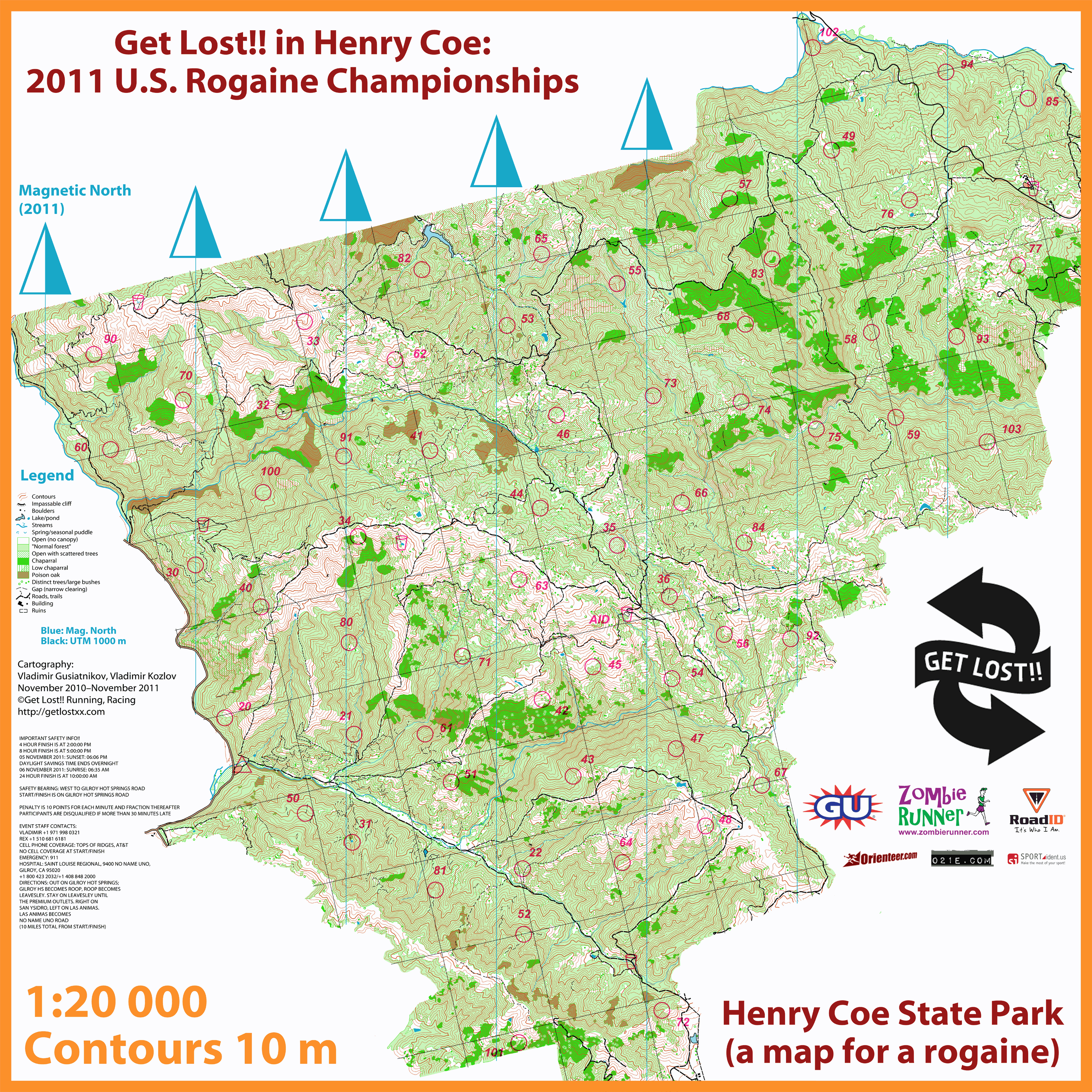
|
Created:
15 December 2010 |
© 2010–2012
Get Lost!! Running, Racing, Inc. |
|